Roads of Zardab ( for tourists )
The Zardab region of Azerbaijan republic is located 231km from baku and 35 km from the ucar railway station. The territory bordered with Ucar, Khurdamir, Aghdash, Aghcabedi. If you are planning to drive to Zardob by car, we would recommend you first to get acquainted with the road network of Azerbaijan and the rules applied on these roads. This is a map of the highways ofAzerbaijan (scale 1sm:17 km)The lenghts of the highways of Azerbaijan is abaout 19,000 kilometers. The recquirements applied to entry of automobile vehicles into the republic have been toughened since 16 august 2014, which do not meet euro-4 standarts. At present, automobile owners are required to submit documents confirming compliance with these standarts when entering the territory of the republic for customs clearance.
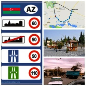
Speed limitation
Speed limitations are as follows ( unless otherwise indicated in the
traffic sign )
For Trucks:
-
Settlements – 60 km/h
Settlements – 60 km/h
-
Out of the settlements –
70 km/h
-
One-way two-lane roads –
70 km/h
-
On the highway – 90 km/h
For cars ( up to 3,5 ton )
-
Settlements – 60 km/h
-
Out of the settlements –
90 km/h
-
One-way two-lane roads –
90 km/h
-
On the highway – 110 km/h
Price of Fuel ( from 15.07.2017 )
• Gasoline (Aİ-80) — AZN 0.70 (€ 0.374)
• Gasoline(Aİ-92) — AZN 0.90 (€ 0.500)
• Gasoline (Aİ-95) — AZN 0.95 (€ 0.508)
• Gasoline (Aİ-98) — AZN 1.03 (€ 0.551)
• Diesel — AZN 0.60 (€ 0.321)
Emergency
numbers
Fire – 101
Police – 102
Ambulance – 103
Ambulance – 103
Traffic police – 126
Emergency situation – 112
Emergency situation – 112
It
is important to have them in the car:
- Medical bag
- Fire extinguisher
- Accident sign
Roads of Zardab
 Reviewed by Camil Asad
on
27.7.17
Rating:
 Reviewed by Camil Asad
on
27.7.17
Rating:


Hiç yorum yok: